Just another manic Monday.
Just another manic Monday.
I think this morning’s long term look at the passage making weather may make some of you smile. Standard caveats apply and please remember that the forecasts have been changing quite a bit - meaning there is uncertainty in the modeling and 2) I am not a meteorologist… just a simple sailor sharing his thoughts and ideas on what I am seeing using the forecasting and routing tools I use when I make passages.
In fact, I would encourage anyone who is looking to make a trip to consider hiring a weather router. Weather routers are services that have access to all of the forecasting tools and years and experience interpreting those tools to help boaters of all kinds make the best possible choices. I personally use them to help backstop my own ideas and forecasts. They are reasonably priced and well worth it in my mind.
I regularly use three different services in addition to all the calculations I use on my own. Here are three you should look at:
WRI - Weather Routing Inc. - Is a full service weather and routing provider that I have used when sailing with the World Cruising Club Events like the Caribbean 1500 and the ARC January. They have also been a stalwart supporter of the passages I have done with 59 North on Isbjorn and Icebear. I am personally a big fan of their services especially for offshore and coastal sailing. They are SUPER responsive to emails (including from sea) and I like the way the information is conveyed. That said, for some it can be a bit “nerdy.” But I personally REALLY like that. Further, if you have good access to the internet (think coastal or if you are using an internet service at sea that can handle it) they have some fairly sophisticated additional maps and materials. I usually am pulling emails over IridiumGO! which means I have come to love their written descriptions. For whatever its worth, I use them every chance I have when I am doing deliveries and offshore teaching events.
Commanders Weather - When I am racing, I often have Commanders Weather put together forecasts. I find them really accurate for venues like Key West, Miami and others; and their hour by hour shift/velocity charts are super useful along with little notes for what to look for if changes is coming. I have also used Commanders for passage making and they offer really nice packages that are cost conscientious and adaptable while underway. If I was doing a Bermuda Race or Nassau Cup… I’d be ringing up Cammanders to support.
Chris Parker and Marine Weather Center - I don’t know of anyone who is a better resource for Caribbean weather information. If you are looking for solid forecasting to and while in the islands - Chris Parker’s tools are worth the cost. He also provides daily emails (better than this series) and even SSB broadcasts that are a HUGE help to making sailing safer and more fun.
If you are pointing south this winter. Get a router. Now back to the weather forecasting version of the Gong Show…

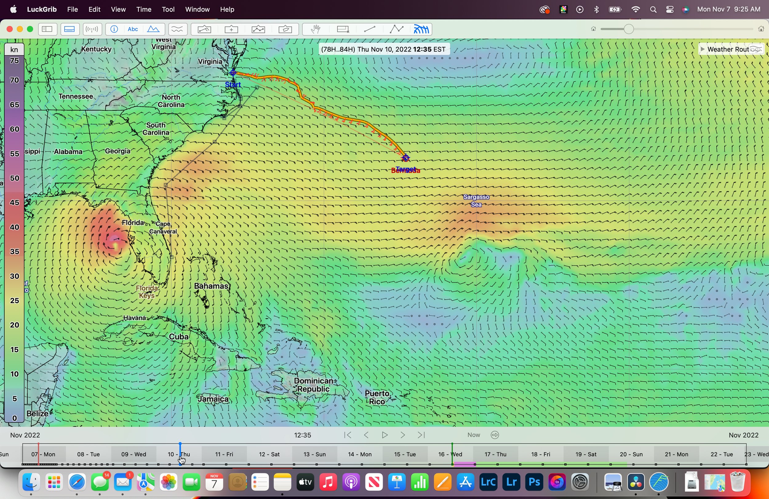
Here is a look at Monday November 7, mid-day.
Things are looking fairly stable, but there are forces at work that are going to make this snap shot a much more tumultuous place for anyone looking to sail to Florida, the Bahamas or Bermuda. In fact… its looks like these that remind me that 20 years ago when I was just starting these kinds of adventures… I probably would have left. As you will see it would have likely lead to one of my sea stories… something I am gaining more pride in NOT having these days vs having.

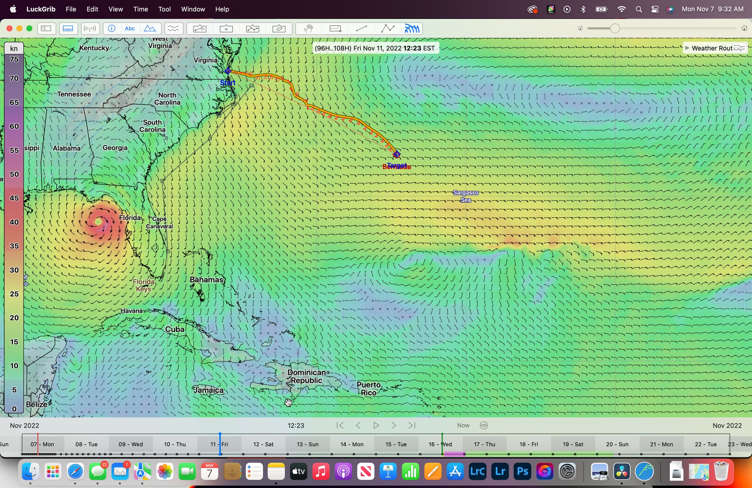
Tuesday mid-day
That wind field south Cape Hatteras blows us. As stated earlier wave heights are pretty big in the Gulf Stream… not a good day to try to cross. In fact, in the image above you can see my black line indicating the Western Wall of the Gulf Stream. That red blotch just off South Carolina is producing some seas in the 15-20 foot range according to the wave model. No thank you.
That said, I think if you are sitting in Morehead City or Wrightsville Beach… this could be a good day to make some miles. Especially if you are pointing at Charleston as a pause point. Get those jibs winged out and start flying!

Wednesday, November 9, 2022
Assuming that the election night didn’t burn the country to the ground; we have some interesting weather coming our way.
There is a low pressure system that is forming just north of the Bahamas. This seems weird to me for a few reasons. The first reason is that just 48 hours ago this system was forecasted to start on the Gulf side - I’d be curious to know what pushed it east. The second - which you will see in the next image - is that this system tracks EAST TO WEST. That is of particular interest to me because I am scheduled to be sailing in St. Petersburg Florida in the Mixed Plus event hosted by the St. Petersburg Yacht Club. Right now, forecasted conditions for Wednesday, Thursday and much of Friday are beyond “up range.” They are unassailable.
Check out the marine forecast for Tampa Bay right now…
GMZ830-072215-
Tampa Bay waters-
445 AM EST Mon Nov 7 2022
.TODAY...Northeast winds 10 to 15 knots with gusts up to
20 knots. Bay and inland waters a moderate chop.
.TONIGHT...Northeast winds 10 to 15 knots with gusts up to
20 knots. Bay and inland waters a moderate chop.
.TUESDAY...Northeast winds 10 to 15 knots, increasing to 15 to
20 knots in the afternoon. Bay and inland waters choppy.
.TUESDAY NIGHT...Northeast winds 15 to 20 knots with gusts up to
25 knots. Bay and inland waters choppy.
.WEDNESDAY...North winds 15 to 20 knots with gusts up to
30 knots. Bay and inland waters choppy. A chance of showers in
the afternoon.
.WEDNESDAY NIGHT...North winds 15 to 20 knots with gusts up to
30 knots, increasing to 30 to 35 knots with gusts up to 50 knots
after midnight. Bay and inland waters extremely rough. A chance
of showers with a slight chance of thunderstorms.
.THURSDAY...Northwest winds 35 to 45 knots with gusts up to
60 knots. Bay and inland waters extremely rough. A slight chance
of thunderstorms. A chance of showers in the morning, then
showers likely in the afternoon.
.THURSDAY NIGHT...West winds 35 to 40 knots with gusts up to
55 knots, diminishing to 10 to 15 knots with gusts up to 25 knots
after midnight. Bay and inland waters extremely rough. A slight
chance of thunderstorms. Showers likely early in the evening,
then a chance of showers in the late evening and overnight.
.FRIDAY...West winds 10 to 15 knots with gusts up to 25 knots.
Bay and inland waters a moderate chop. A chance of showers with a
slight chance of thunderstorms.
Winds and waves higher in and near thunderstorms.
Thursday Mid day
That system that intensified over the mid-Florida segment of the Gulf Stream has now made its way to the Tampa Bay Area. While this likely means no sailing for us, there are opportunities for those of you looking to escape the Chesapeake. While E’ly winds often mean rain, they can also mean some sweet close reaching down the VA/NC beach. Hatteras in an E’ly is OK - although the lee shore aspect does make me nervous.
BTW - that’s a point worth making. If you are making your first trip down the coast and have opted to go “outside” - meaning you are rounding Cape Hatteras; understand that once you have left the Chesapeake Bay you don’t have another stop until you reach Beaufort/Morehead City. Oregon Inlet isn’t an option and this segment of coast is affectionately called the graveyard of the Atlantic for a reason.
If this forecast holds true, I will send some cool pictures from the Dali Museum in St. Pete - because we won’t be sailing.
Friday - mid-day
Looking at this, I think those of you going coastal; could still find enough E’ly in the angle to make sailing from Beaufort/Morehead City to Wrightsville Beach comfortable. There could be a bit of sea state that might make that more challenging than average - but it looks doable. I wouldn’t want to set my sights on things much further south as the winds are more S’ly as you get further south and that red dot in the armpit of Florida should make you nervous.
If you are in the Chesapeake… re-read that last sentence. While this looks like a viable go east moment… I worry because you can be fairly certain that thing is going to head NE and could bring with it some punch. Oh yeah… and there is that Friday departure thing we talked about earlier.
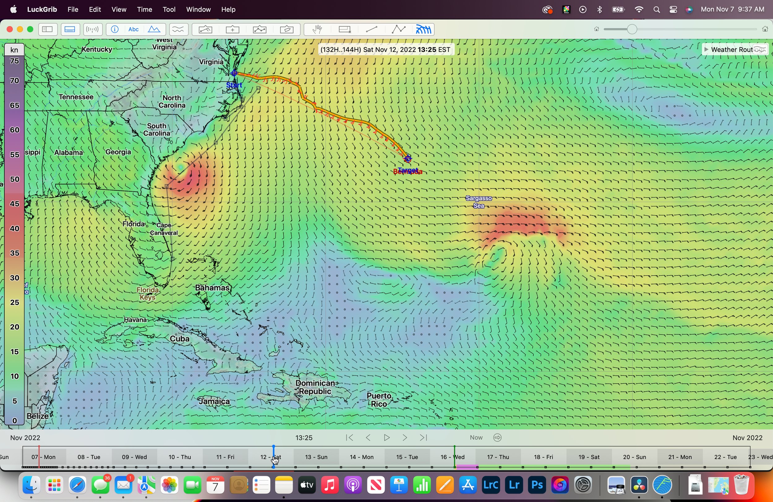
Saturday, November 12 mid-day
As expected, that little bomb has trucked across Souther Georgia like Sherman and has found the warm and empowering waters of the Gulf Stream. We can see in the image above that there is some strengthening. This sort of shuts down the corridor and makes heading to Bermuda risky in my eyes. Better to spend the day at the local public library reading a book, or inventory all of your tools, or clean the bilges.

Sunday, November 13 mid-day
Coastal sailors… get your groove on. What an awesome day to head South! Flat water and firm pressure should mean some sweet sailing for those of you just leaving the Bay and beyond.
If you are thinking of Bermuda and beyond… I would be watching the Gulf Stream report to get a sense of how sporty it is. It has been a tumultuous few days and the stream is probably still bumpy. The elements in play here suggest that the winds will turn E’ly in soon… so even if you did manage a comfortable stream crossing - you’d be setting your self up for some upwind work following.

Monday, November 14 2022
Things look organized. This is one of the first images we’ve seen without big red blobs. I still am not a fan of crossing the Gulf Stream when the winds have an N in their description. I might be willing to look past that if winds were sub-12kts… and that is coming.
That said, some of you will have been waiting long enough to be willing to make the jump now and take advantage of good winds and suffer the bumpy seas.
Coastal sailors… Get out of here. These are salad days.

Tuesday November 15, 2022
If you are coastal or have the Bahamas on your mind… put the pedal to the metal. This is a great time to be making big miles. Conditions look great- the only bummer is you are missing a cool part of America by not stopping at every inlet you can. Maybe next year.
If you jumped off and are making making miles to the East things probably feel pretty good.

Wednesday, November 16 mid day
Coastal sailors are still making tracks. If you have been patiently waiting to exit the bay… this is my kind of day to do it. As I’ve said before, if I had my druthers I would motor across the stream; and when I see a block of very light winds at the mouth of the Chesapeake extending towards to Western Wall of the Gulf Stream, I fill the tanks and cans and hammer down. There is plenty of epic sailing on the horizon - so let’s get across the crux of the early part of this trip in comfort.
If you look at the image above, you can see that there is a weather route generated by LuckGrib for a trip I am planning on making about this time. I am playing with departure dates a bit because, frankly, Thursday November 17th looks like it might be better and actually add little time to the total trip - but that remains TBD. For the sake of the file/route - I have a 1700 departure from the Bay on Wednesday November 16… which means departed Annapolis the previous morning.

Thursday, November 17 mid day
Coastal sailors, you’ve likely started your engines and are enjoying some fine fall cruising.
Bermuda and beyond sailors… this looks like I best window for escaping the Bay. There is sailable winds for those who are anxious to put up the sails and there are good conditions for pushing hard to get well clear of the stream and any associated eddies. Changes are on the horizon, so we might see a little bit of everything here.

Friday November 18, 2022
Happy Friday. What a great day for a silly hat celebration. Friday brings a transition to a building S’ly component that will have us enjoying starboard tack reaching conditions with the bow pointed at Bermuda. That always feels good.
Coastal sailors; if you are are still pointed south you probably are experiencing headwinds that would have me on the beach; but not so strong that the hardiest of you will keep going.
As you can see in the routing prediction above, we’re close reaching in 15kts. While that might not be quite as comfortable as broad reaching in 20… it is a workable angle.
The cold front that passed over the East Coast of the US, has ushered in NW winds for most of the SE Coast, and coastal cruisers should be happy.
If you have made it to Florida… this could be a good day to make the jump across the steam to the Bahamas - especially if you are leaving from West Palm or further south.

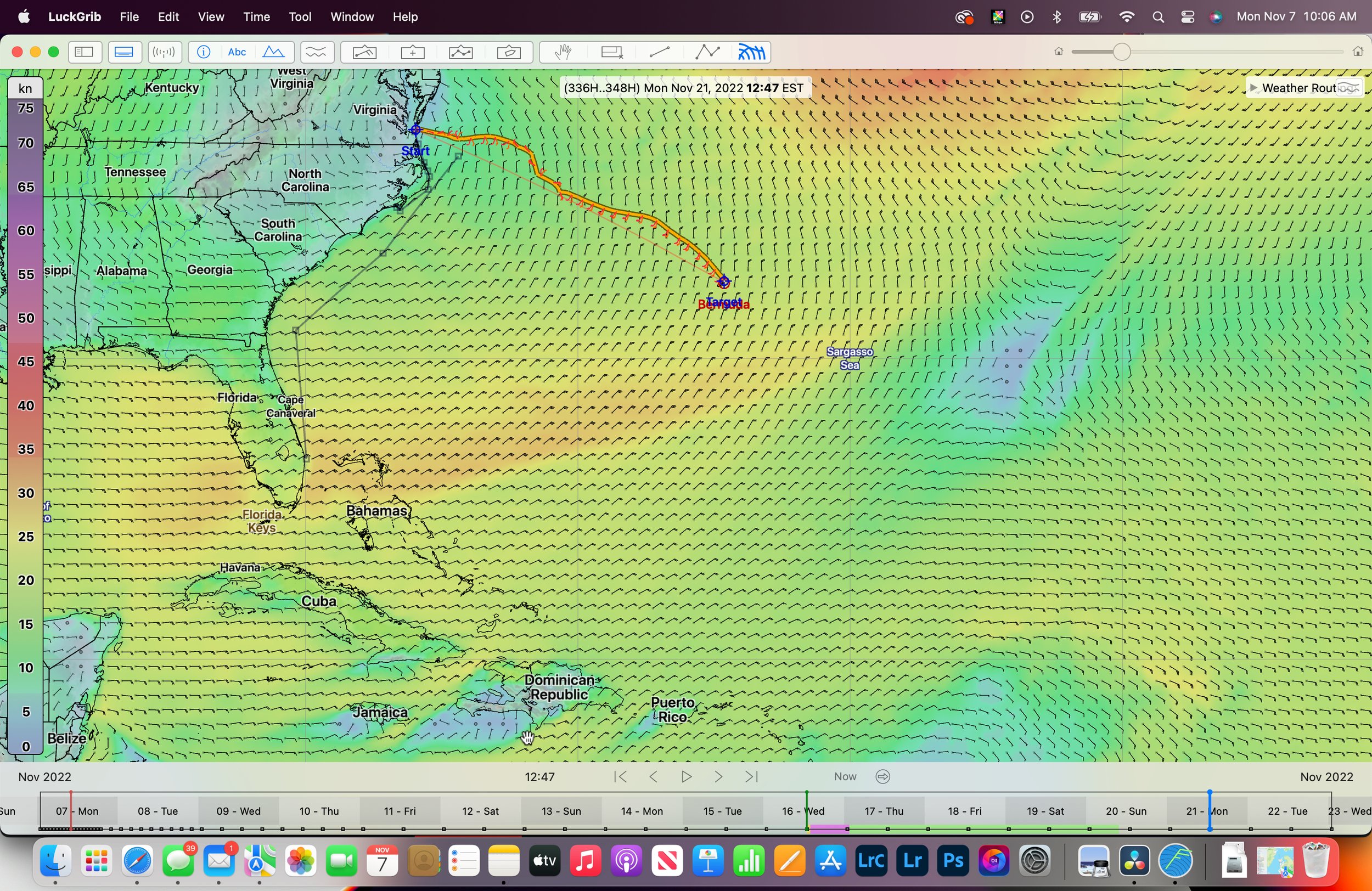
Sunday, November 20, 2022
Assuming you made it across the stream; you are making good miles towards Bermuda and beyond. As you can see if you are thinking Caribbean or BVI… the E’ly winds that will get you south are fully “in” in this image. I would be trying to get to that light patch south of Bermuda so I could hammer down due east. The closer you can get to 60° W before you turn south… the happier you will be.
This day makes me look back at our Wednesday departure and has me thinking Thursday would make for better sailing without much penalty on arrival time.
Sunday, November 21 mid day
This is a great sailing day across the image. Whether you are pointed E or S; things are good for sailors across the discussed routes.
Stay tuned for more. Keep those questions coming!