I just want to get south.
If you are sitting in the Chesapeake Bay right now, thinking of escaping to Florida, the Bahamas, Bermuda or the Caribbean… this is always a frustrating time. This year might be more frustrating than average as there is a fair bit of late season activity standing between the comfort of the Chesapeake and the adventure of points further south.
My first suggestion to all you cruisers… consider taking a turning leaf cruise. For those of you in the Norfolk/Hampton Roads area there are still leaves on the trees - so grab a box of your favorite Turning Leaf wine, follow the John Smith trail or sail the historic path of the revolutionary war naval battles and get some late season cruising in. You have time and if you are patient - your weather window will open up.
For most of you, you want to know when you go because you want to go NOW. I get it; even if I don’t agree with it. As someone who often is delivering a boat on a timeline that isn’t totally in my own control; I understand the desire to find a forecast that we think we can fit into rather than looking for one that fits into us.
So let’s have a look at what is happening out there and investigate the long term outlook.

Sunday, November 6
This first image is what is forecasted for tomorrow, Sunday November 6th. From the mouth of the Chesapeake to Hatteras light S’ly winds would make the initial leg a bit of a bash - but if you were trying to get to Florida or even the Bahamas this might look like a good day to spring “around the corner” which would free you to harbor hop on good days from Beaufort to Wrightsville Beach and on and on.
If you are pointed to the Caribbean or Bermuda… Saturday isn’t a great day to head SE. But it could be a great day to spring across the Gulf Stream. I love crossing the stream under motor or with engine assist. If I can I always shoot to make that 100 miles in the lightest conditions possible and find the fuel burn to be worth it for the comfort. Once across - especially if Bermuda is the target; I can manage S’ly and N’ly winds which tend to dominate the scene. Before I left the Chesapeake I’d want to know what is coming… so let’s take a look at Monday.

Mid-day Monday November 7
Mid-day Monday November 7 is still looking good for those who are pointed down the coast and have made arrangements for places to stay in the coastal pause points like Beaufort, Moorhead City or Wrightsville Beach. If you are pointed to Bermuda, pay attention to the band of very light winds just north of the rhumb line. First, it is a common harbinger of change, second if you look to the west you can see the indicators of a cold front coming. Finally, to the SE of the rhumb line you a see there is some low pressure developing that looks like it is getting organized. Lots happening here. That said… if you went for the crossing… I personally would keep burning fuel and head DUE EAST to stay in the light stuff… because we have a pretty good idea what’s coming next.
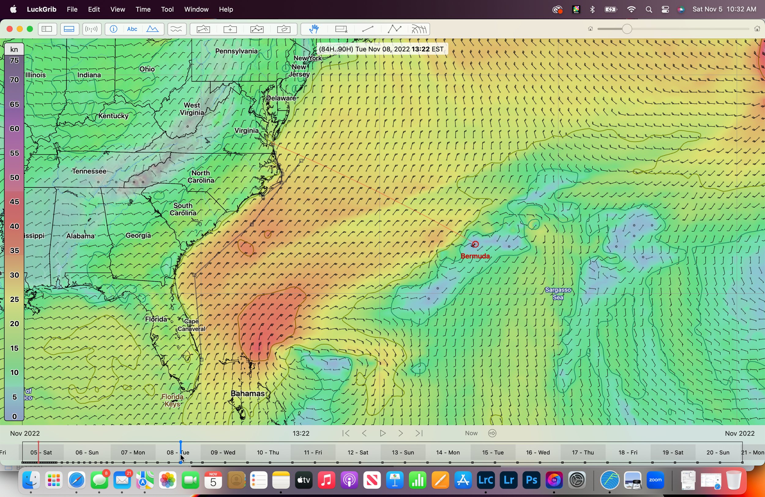
Tuesday, November 8
This is the GFS forecasted wind for mid-day on Tuesday November 8. If you are Florida or Bahamas bound… things are getting spicy. Wave heights south of Hatteras in the Gulf Stream are in excess of 15’ and in fact, waves are forecasted to be above 10’ (3 meters) on either side of the stream. Yes, you’ve got strong winds blowing in the right direction; but it’s gonna be big and it’s risky. If this forecast is understated by 10% things get really tough really fast. With more than half the day in darkness this time of year - these conditions would be hard on crews and REALLY hard on short handed teams. Kind of makes you wish you got a boat that fit down the ditch doesn’t it?
If you are Bermuda or Caribbean bound; that play to stay as far north of the rhumb line to Bermuda has paid off. Which close reaching in 25+ kts of wind is no picnic; you can count on the winds continuing to shift right - clock - which will mean the more N’y course you can save early will allow you to sail the impending header to a tack somewhere just south of the rhumb line and then allow you to slowly ease sheets over the coming days. About now you might be wondering why you didn’t get another box of Turning Leaf and extend that Chesapeake Bay Cruise.

Wednesday, November 9
This is Wednesday mid-day. Still spicy south of Hatteras and if you pointed at Bermuda…. Well.... You are sailing upwind in up range conditions. I hope you made lots of soup, built your sails to offshore standards, have a third reef and took your sea-sickness meds. It’s a tough patch.
For those of you looking at this thinking; well if I was pointed at Tortola this might be perfect! I can get across the stream in the light stuff, and then ride these NE’ly winds right at Tortola… I think the problem you will have comes later in the trip. If you can’t get enough E in your course early… when you reach the prevailing E’ly winds further south… it becomes a long slog to windward.
One thing this image doesn’t show is that it was REALLY windy overnight - especially for those of you who were closer to the coast. A few 35’s showed in the grib file which is always exciting no matter when, where or what direction.

Thursday, November 10
Thursday mid-day. Forecast confidence is pretty low at this point - but let’s work with what we’ve got.
If you were coastal or if you waited in the Bay for your window (how was YOUR Turning Leaf cruise?) this looks like a day where you can finally escape. Wind is fresh, but in the right direction for getting down the beach or around the corner. From Little Creek to Wrightsville Beach, I think you’ll start to see boats coming off their anchors and reaching south. Note that sea state’s might be higher than average given the preceding few days.
If you are thinking Bermuda or heaven forbid halfway there… you are still sailing upwind in 15-20kts of wind. Not a lot of fun. If you were thinking of the Caribbean, left already and are tired of taking it straight on the nose… you’ve probably started sailing south. But if you look at that image above - you will see that you are heading for some very calm areas that will likely have BIG swell in them. Keep going east if you can.

Friday, November 11
Friday November 11 mid day
Friday has some interesting things going on. First, while it won’t impact those of you trying to escape the east coast… for those of us sailing the J/70 Mixed Plus event at the St. Petersburg Yacht Club; we’ve got the real threat of an organized storm system churning just off the coast. That will make for some exciting practice days and some windy racing if it comes to be.
Coastal cruisers - things are looking pretty good especially if you’ve gotten around Hatteras. If you are just finishing your Turning Leaf cruise and are thinking of making your move today or tomorrow… wait and see what develops.
Bermuda and Caribbean bound sailors. I am sorry. Firm E’ly winds make heading this way a real challenge. This pattern is just what you want once you get to about 60W… but until then this makes heading this way a no go for me; and tough sledding for those of you who did decide to push for it.

Saturday, November 12
Saturday, November 12 mid-day
If I was sailing down the beach… I’d be looking for a cute anchorage or a snug marina and pausing for the day. You can see the cold front its that band that divides the N’ly winds from the S’ly winds. IF I was fully crewed I might think about escaping from the Chesapeake and heading towards Hatteras. The challenge being that you will be FLYING and it might impact your timing around Hatteras. I personally prefer day time rounding in light winds; but if NE’ly is workable - with there being a couple of hours of bumpy stuff before you find refuge in the lee of the lower outer banks. That said, I would want to know I can get into a safe spot after the rounding to lick wounds, recover constitutions and relax my nerves.
If you are in the Ocean - you get a little reprieve from the E’ly winds and should be able to see sheets on starboard tack for a bit. Note that there is a disturbance to the E of Bermuda that could be a little bomb of weather.
Also… remember that storm I talked about being on the gulf side of Florida… well watch what it does when it hits the warm water of the Gulf Stream. In the image above you can just see it starting to regain energy and power.

Sunday, November 13
If you were Bermuda bound…. Yikes. If you were still in the Bay and thinking of heading to Bermuda or the Caribbean today. Think again. This little Carolina clipper will make the Gulf Stream and near it more than just a bumpy road.
If you go far enough to the E before this thing showed up, then you might be happily sailing in squally conditions in a firm southerly and making good distance towards Bermuda and points east.
Coastal sailors south of Hatteras…. These are great conditions to sail in and this could be an awesome day to make some miles.

Monday November 14th…. Things are starting to look like they are supposed to.
This looks a little more “normal.” A high pressure system over the lower Appalachian is creating broad N’ly winds that might make the Gulf Stream a little uncomfortable - especially if there is residual seas state. If I had to guess waves would be 10-14 in the Gulf Stream and sub-9 outside of it. If you are going coastal… these are good days.

Tuesday November 15, 2022
Coastal sailors rejoice, break out the spinnakers and make some miles. Your patience has been rewarded with outstanding conditions for getting south and enjoying classic fall cruising weather.
If you are thinking of Bermuda and beyond, this is a decent window to escape - although bad news may be on the horizon and you just might have to dust off your extra patience. Note that light winds to the north of the mouth of the Bay. It might make sense to make a straight E’ly push even if you intercept these lighter conditions in an effort to be in position for what is likely coming next.
Wednesday, November 16 is still looking great for the coastal sailors. It has me wishing I was thinking Bahamas not Bermuda! Keep making those miles and making those memories. It’s worth mentioning that for me - having sailed to the Bahamas and Florida many times, I am a big fan of one Gulf Stream crossing. Meaning, I tend to sail coastal until Miami if I am planning to sail to the Abacos or beyond. I’ve certainly gone direct; but more often I’ve been happier being coastal and finding a window further south to make my crossing. Longer. Yes. Safer. Yes.
If you are Bermuda and beyond bound I have one word for you. Easterly. Winds are reasonable; just from the wrong direction. If you are looking at this as a departure day, I think you can get out of the Bay and to the stream well. You might even consider going coastal to Hatteras to buy you some time before making the crossing. But be honest… this is a straight upwind 18-24kts forecast. Does that fit in your go/no go parameters?

Thursday, November 17
If you thought about heading to Hatteras to make your crossing angle better; well… that might have been a mistake. Here comes another little low pressure system that will make “the corner” sporty. If you went direct; you are probably on starboard tack, sailing close hauled trying to get E and away from the track of this thing.
If you are fortunate enough to already be E… well… you are still sailing upwind but in more manageable conditions.
If you are still waiting in the Chesapeake… know that your time is coming. If you need some recommendations on hikes, wineries or things to do to keep you occupied - let me know. Also, recognize that we are WAY off the range of high confidence forecasting. It will change many times between today when you are reading this and Thursday November 17.

Friday, November 18
Things are pretty interesting here. Coastal sailors can escape; and bold sailors willing to gamble on 16 hours of tough sledding in the Gulf Stream have a real opportunity here. As I’ve mentioned above I will happily burn dead dinosaur bones to get across the Gulf Stream. An early push could have you across the stream before that blob of NE’ly crap descends. It is too far out to plan on this - but these are the opportunities that smart cruisers stay nimble and watchful for.
Coastal and Bahamas folks. If you aren’t there already you are having a good run of things. Even if you haven’t left yet… this would be a good day to go.
Of course there is that old superstition about leaving on a Friday…. Wait, didn’t you technically leave several weeks ago? And THAT departure day wasn’t a Friday.
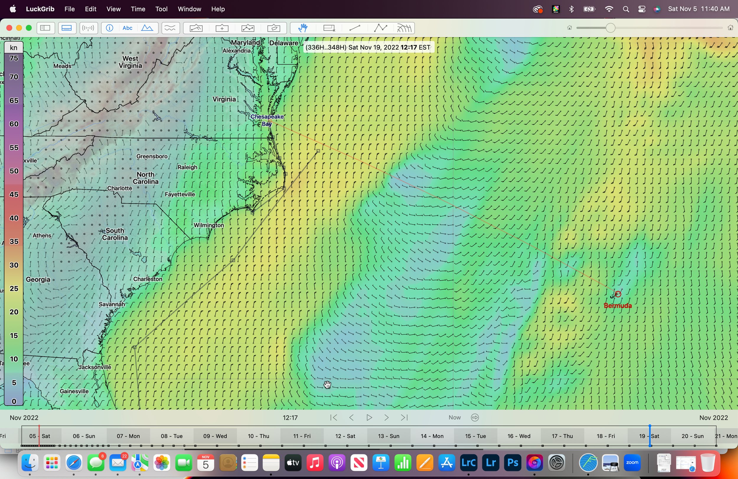
Saturday November 19, 2022
Finally a day we can all celebrate. If you are coastal; enjoy. If you made it across the stream; standby for the sleigh ride. If you are just leaving… The opening 100 miles before the stream will be awesome - expect it to be big but likely manageable for the crossing. I try not to go across in these sorts of conditions - but your milage may vary.
Sunday November 20.
Another day that is more “typical” of what I would expect to see. IF by some chance you had made it to Bermuda already - this is a class looking day to leave St. Georges and march E’ly. The further you get the better your trip to the Caribbean will be. If you are coastal - enjoy. I you are looking to leave the Chesapeake - this looks great for an Iron Genoa escape.
BTW - Given that this is 16 days away… a few things contribute to the more “normal” look. The first is that at 16 days the model is more heavily relying on historical data and so it likely looks normal because of the historical trend. Second… the weather pattern that used to signal that after November 1 things are settled is changing. I tend to think December 1 is the new November 1 and because of that I would expect to see fewer systems as times marches on.
OK… That’s it for this morning. Stand by for more tomorrow.